
About the Blog: We started RVing in 2019, but did not decide to start blogging about our experiences until 2021. So, we have some catching up to do. We’ll sprinkle in some new present-day stories as they happen. But if you have time, start at the beginning. You’ll learn (and hopefully laugh) a lot.
Looking for a particular blog topic?
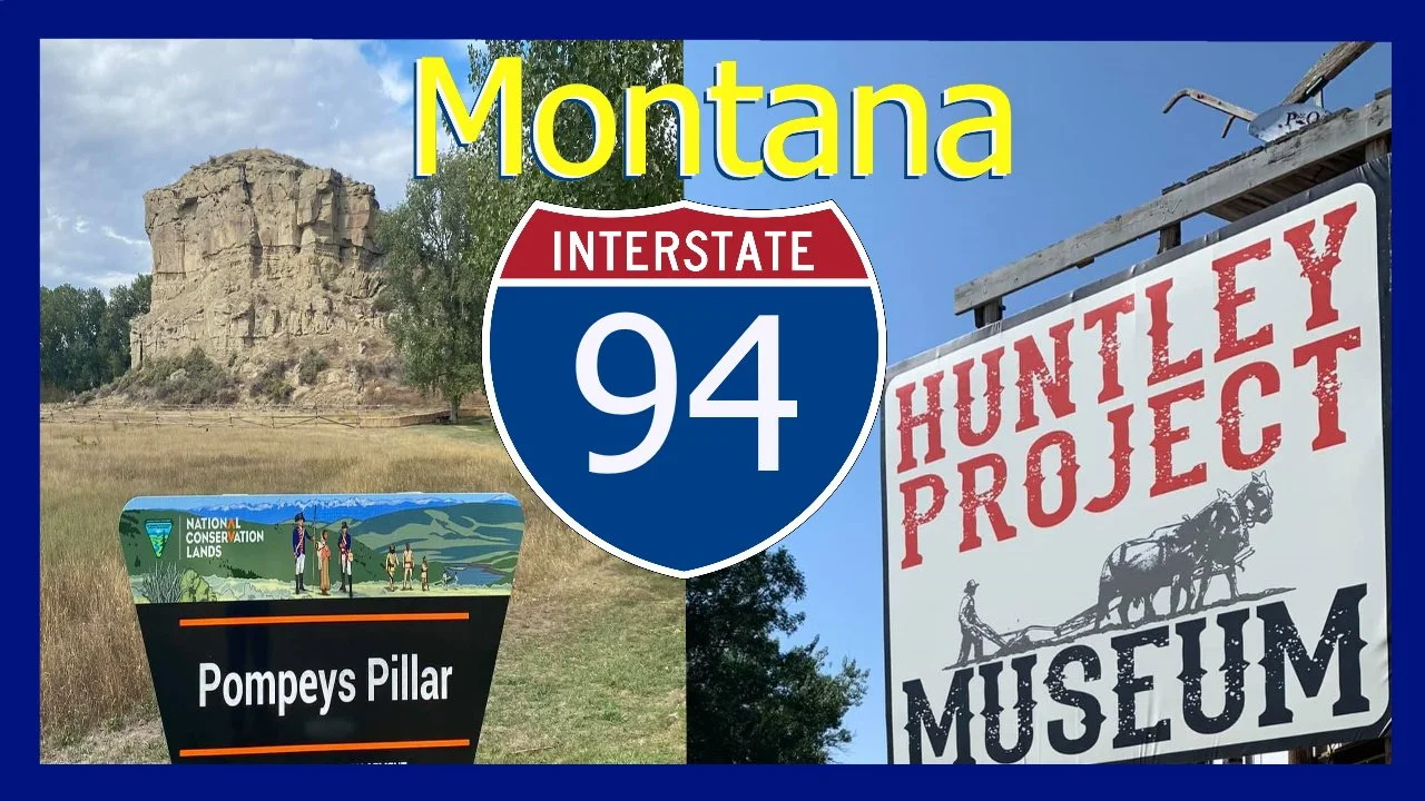
Our Harvest Host Stay at the Huntley Project Museum and Visit to Pompeys Pillar
After visiting Yellowstone National Park, we set out in our RV for Rapid City, South Dakota. On our way, we decided to spend a night at the Huntley Project Museum. Of note, there’s also a section of the museum devoted to Lewis & Clark. Captain Clark traveled down the river in the area on July 25, 1806, and just up the road about 15 minutes is Pompeys Pillar National Monument.
Where: Huntley Project Museum
When: June 22, 2021
Cost: $0 (we made a $20 donation to the museum)
Bucket List: Pompeys Pillar
After visiting Yellowstone National Park, we set out in our RV for Rapid City, South Dakota. On our way, we decided to spend a night at the Huntley Project Museum. The museum is a Harvest Hosts venue so that is how the place got on our radar. As a member of Harvest Hosts, we are able to dry camp at various breweries, wineries, farms, and museums for free, and are only asked to patronize the establishments in some way. It’s a win-win for both.
The museum can comfortably accommodate several RVs. There’s a very flat grassy area next to the road and museum’s entrance designated for RVers. Of course, after we parked and got set up, we ventured inside to learn what it was all about.
What is the Huntley Project Museum?

Huntley Project Museum — Irrigation Information
The “Huntley Project” refers to a Bureau of Reclamation irrigation project that began in 1907. Yes, the focus of museum is about ditch digging! The museum digs in (pun intended) to both the history and technological achievement of the project. Prior to the project, the scarcity of water dictated land use and settlement in the area, and the museum tells the story of the pioneers and workers who dug the canal so that it could be farmed today.
The project’s construction was delayed and way over budget. When President Teddy Roosevelt opened the area for homesteading, thousands of homesteaders wanted land while the area would only support a few hundred farms. Many people who signed up had no desire to farm. After a lottery, only 76 applicants went through the whole filing process so the project got off to a very slow start. Then, some of the land was water-logged because of drainage issues. Years later, the natural flow of the Yellowstone did not convey enough water into the main canal so that a dam had to be built. Learning all of this just made me appreciate more what goes into farming in such semiarid regions. Most people don’t think much about how important infrastructure projects like this affect them, and that is why I liked the museum so much. It really made me think.

Huntley Project Museum - Schoolhouse
The museum is more than the irrigation project though. It’s about the history of the entire region. There are 18 homestead buildings that contain elements of an old schoolhouse, general store, bank, and other turn-of-the-century collections. The museum boasts hundreds of old farm implements and thousands of artifacts donated by the locals.
Of note, there’s also a section of the museum devoted to Lewis & Clark. Captain Clark traveled down the river in the area on July 25, 1806, and just up the road about 15 minutes is Pompeys Pillar National Monument.
Pompeys Pillar National Monument
Captain William Clark’s journal entry on July 25, 1806 reads:

Pompeys Pillar - Captain Lewis July 25, 1806 Journal Entry
Situated in an extensive bottom on the Stard. Side of the river & 250 paces from it. this rock I ascended and from it's top had a most extensive view in every direction. This rock which I shall Call Pompy’s Tower is 200 feet high and 400 paces in secumphrance and only axcessable on one Side which is from the N. E the other parts of it being a perpendicular Clift of lightish Coloured gritty rock on the top there is a tolerable Soil of about 5 or 6 feet thick Covered with Short grass. The Indians have made 2 piles of Stone on the top of this Tower. The nativs have ingraved on the face of this rock the figures of animals &c. near which I marked my name and the day of the month & year. From the top of this Tower I Could discover two low Mountains & the Rocky Mts. covered with Snow S W. one of them appeard to be extencive and bore S. 15° E. about 40 miles. the other I take to be what the indians Call the Little wolf Mnt. I can only see the Southern extremity of it which bears N 55° W about 35 Miles. The plains to the South rise from the distance of about 6 miles the width of the bottom gradually to the mountains in that derection. a large Creek [4] with an extencive Vally the direction of which is S. 25° E. meanders boutifully through this plain. a range of high land Covered with pine appears to run in a N. & S. direction approaching the river below. on the Northerly Side of the river high romantic Clifts approach & jut over the water for Some distance both above and below. a large Brook which at this time has Some running muddy water falls in to the Rochejhone imediately opposit Pompys Tower. back from the river for Some distance on that Side the hills are ruged & some pine back the plains are open and extensive. after Satisfying my Self Sufficiently in this delightfull prospect of the extensive Country around, and the emence herds of Buffalow, Elk and wolves in which it abounded, I decended and proceeded on….
That journal entry is remarkable for at least three reasons:
First, Captain Clark’s actually engraved his name on the rock! Indeed, his signature on the rock formation is the only on-site evidence that remains of the team's journey through the west.
Second, the journal entry readily shows the significance of the rock formation to the Native Americans.
Third, Captain Clark instantly appreciated the majestic views from the landmark.
For clarity, Captain Lewis was not part of the exploratory team that visited the site. On July 3, 1806, after crossing the Continental Divide, the Corps of Discovery split into separate groups so that Captain Lewis could explore the Marias River. The expedition stayed separated until they reached the confluence of the Yellowstone and Missouri Rivers. During their separation, Captain Clark visited the rock, and reportedly named it after Sacagawea’s son, Jean Baptiste Charbonneau, whom he had nicknamed “Pomp.” Either Nicholas Biddle or Paul Allen renamed the rock as "Pompey's pillar" as part of their 1814 publication of the expedition.

William Clark’s signature at Pompeys Pillar
As a L&C fan, I was quite excited to see Captain’s Clark signature. Yet, the inscription almost didn’t survive the passage of time. As the Northern Pacific Railroad was developing in Yellowstone Valley in the 1870s, they recognized that vandalism was rapidly effacing the etching so the railroad installed a grating over the inscription. The grate, however, did not stop weathering and erosion. Later, in 1926, the Daughters of the American Revolution hired a gravestone cutter to deepen and freshen the inscription. Today, the inscription sits behind a transparent glass case.
In addition to Captain Clark’s engraving, Pompeys Pillar is marked with thousands other etchings, petroglyphs, and pictographs. Native Americans lived in the region, and flags representing the federally recognized tribes of the Blackfeet, Flathead, Little Shell, Rochy Boys, Fort Belknap, and Fort Peek Trips are on display near the park’s entrance. Archaeological evidence includes stone tools and butchered bison near the monument and adjacent Yellowstone River.
The Crow referred to the pillar the “Mountain Lions Lodge” or “Where the Lion Preys.” It’s unclear whether that name is because part of the formation looks like a mountain lion’s head or whether mountain lions were in the area.
In 1873, Lt. Col. George Armstrong Custer and his troops were camped near the pillar. As the men were taking a swim in the river, several the Sioux Native Americans fired upon them. Thus, Pompeys Pillar has some historical significance beyond just Captain Clark.
The national monument contains an Interpretive Center where visitors can learn more about the site. It includes a 20-30 minute movie called “About the Expedition” that is worth watching while you are there. You’ll likely become a Lewis & Clark fan just like me!